why i love google earth
The first day when i saw data on google earth i just could'bt believe my eyes. I've always been very fond of satellite imagery and all these years i've desperately searched for maps,images but was never satisfied .
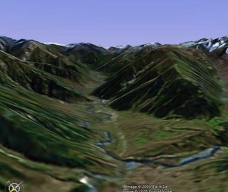
At first it was to much for me to believe that the data was correct but slowly as i explored i realised it was very much authentic Now i'm totally hooked on to google-earth and my area of interests are himalayas,karakorams etc.google earth offers the best way to know the topography,geography of any area. Now i justdont like refering to any atlases. why should i when i have something thats offering me a 3dperspective. and trust me the mountain features,valleys,path of rivers etc you see here are actual scaled replicas. The photographs below prove my point.


The second pic was kind courtesy my dad's when he was posted in valley. after seeing that pic
i thought why not try the same orientation from google earth...
so that was what the first pic was.
The place use see above is Sonamarg which remains cutt of during winters and the river you see is sind. Little ahead lies Zogila pass where the highest tank battle was fought in 47. Also another important place ahead is Baltal , which is the base for starting for Amarnath Cave and from baltal the pilgrimage can be done in a day as opposed to pahalgam which takes 3-4 days.
I even found the place in arunachal where i had stayed for two days just by the topography and later on when i got the coordinates it turned out my judgement was correct :)
Its very easy to locate any place in google earth once you know the coordinates in the form of latitude and longitudes.


0 Comments:
Post a Comment
<< Home